• en
  • pl
  • Log in
  • Register
CIK
CBK
Crisis information sources
CIK Activities
Operational products
Publications
New technologies
  • News
  • Operational products
  • Activities
  • Projects
    • Current projects
    • Finished projects
  • New technologies
  • Publications
  • About Us

Back

Maps for the earthquake in Italy

A magnitude 6.2 earthquake has struck central Italy (100 km north-east of Rome) very early in the morning on 24th August 2016. Area of damage contains several regions, i.a.: Lazio, Abruzzo, Umbria.The most severe damage The towns of Accumoli, Amatrice, Posta and Arquata del Tronto were among the most severly damaged locations. Several aftershocks struck the region over the next few hours. The most powerful had magnitude 5.5. The final number of victims is not yet known, but it reached almost 250 deaths.
Localisation of epicentre of earthquake (source: USGS)

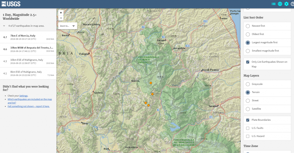
On the website USGS – Earthquake Hazards Program you can trace the course of the earthquake. In application there has been indicated the place of epicenter of the first earthquake and following aftershocks together with a description of their magnitude and time of occurrence. An interactive map shows the epicentre of earthquake and estimated intensity accoring to modified Mercalli scale. There were prepared several maps showing seismic hazard in Italy together with detailed description and community Internet intensity map which shows places where the earthquake was felt the most.

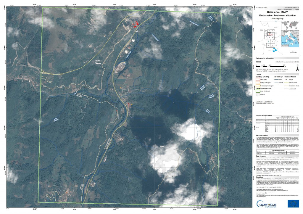
Because of the scale of the disaster, the Copernicus Emergency Management Service (EMS) was activated. The EMS is currently producing reference maps and grading maps showing the scale of damage in areas struck by the earthquake. In order to see all the maps go to the Copernicus EMS: http://emergency.copernicus.eu/mapping/list-of-components/EMSR177#

Map showing the scale of damage in Accumoli (source: Copernicus EMS)
Map showing the scale of damage in Grisciano (source: Copernicus EMS)
Map of intensity of earthquake (source: USGS)
Kategorie:
Ten serwis wykorzystuje pliki cookies.
Korzystanie z witryny oznacza zgodę na ich zapis lub odczyt wg ustawień przeglądarki.
Copyright © 25 All rights reserved.
  • Kontakt
  • Cookies policy
Realizacja: ActiveDesign

Log in

The Address e-mail field is required.
The Address e-mail format is invalid.
The Password field is required.
The Password must be at least 7.
Forgot password?

Reset your password

The Address e-mail field is required.
The Address e-mail format is invalid.

Registration

The Name and last name field is required.
The Name and last name must be at least 7.
The Name and last name may not be greater than 50.
The Address e-mail field is required.
The Address e-mail format is invalid.
The Password field is required.
The Password must be at least 7.
Passwords dont match.